
A magnitude 7.8 earthquake struck Myanmar's Mandalay region on March 28, 2025, rupturing approximately 510 kilometers of the Sagaing Fault. Its southern segment propagated at supershear speed across some 450 km, making it one of the longest continental supershear ruptures ever documented.
An international research team co-led by Prof. MENG Lingsen of the University of California, Los Angeles, and Prof. ZHANG Yunjun of the Aerospace Information Research Institute of the Chinese Academy of Sciences (AIRCAS) has reconstructed the earthquake's rupture process and mapped its damage in unprecedented detail using satellite remote sensing combined with seismic observations. The findings were recently published in Science.
Due to limited ground access to the affected area, satellite remote sensing served as the primary data source for the investigation. The team utilized synthetic aperture radar (SAR) data from China's LuTan-1 satellite—whose main payload was developed by AIRCAS—along with SAR observations from the European Space Agency's Sentinel-1 and Japan's ALOS-2 satellites. Employing the interferometric SAR (InSAR) technique, the researchers generated a high-resolution coseismic surface deformation field. By jointly inverting these deformation data with seismic records, they reconstructed the fault's slip distribution and the earthquake's rupture history.
Analysis reveals the rupture propagated at approximately 5.0 km/s, exceeding the local shear-wave velocity and confirming sustained supershear behavior along a continental strike-slip fault. The research further indicates that fault geometry, long-term stress accumulation, and material contrasts across the fault were key factors enabling the large-scale supershear rupture.
Beyond rupture dynamics, the researchers conducted satellite-based damage assessments, which showed destruction concentrated along the fault—particularly in urban areas such as Mandalay. Integrating high-resolution optical imagery from satellites including China's Jilin-1 and Gaofen series, the team identified the spatial distribution of secondary hazards, such as building collapses, soil liquefaction, and landslides.
"In regions where field investigations are extremely challenging, satellite remote sensing provides a unique way of directly observing earthquake deformation and damage," Prof. ZHANG said. "By combining multi-source SAR data with seismic observations, we were able to reconstruct the rupture process with detail."
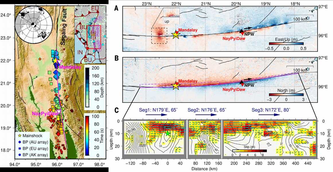
Earthquake overview (left) and ground deformation with slip model (right). (Image by AIRCAS)
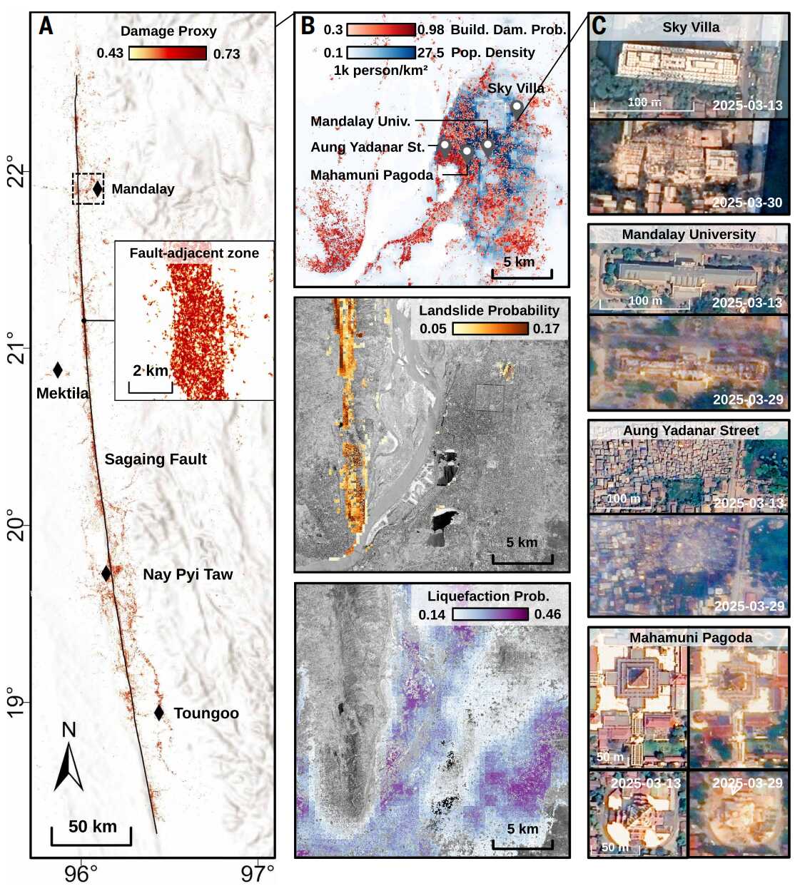
Multihazard analysis of the earthquake region along the Sagaing fault. (Image by AIRCAS)
The millimeter wave cross-track InSAR prototype is provided with three baselines and employs an optical remote sensing equipment stabilization platform. Compared with the short-range multi-baseline millimeter wave InSAR developed by Germany and the single-baseline millime...
China launched a new high-resolution Synthetic Aperture Radar (SAR) imaging satellite from the Taiyuan Satellite Launch Center in northern Shanxi Province on Wednesday. As China's first SAR imaging satellite that is accurate to one meter in distance, it covers the globe w...

86-10-68597521 (day)
86-10-68597289 (night)

52 Sanlihe Rd., Xicheng District,
Beijing, China (100864)
Copyright © 2002 - Chinese Academy of Sciences


