
A research team from the Aerospace Information Research Institute (AIR) of the Chinese Academy of Sciences has released Africa's first high-resolution rice distribution map, featuring a resolution of 20 meters. This dataset of 2023, recently published in Earth System Science Data, provides comprehensive coverage of African countries where national-level rice cultivation areas exceed 5,000 hectares.
The study demonstrates an average classification accuracy exceeding 85%, with a linear correlation (R²) greater than 0.9 when compared to national statistics. The dataset is now openly accessible to the global research community and is expected to play a critical role in supporting the evaluation of the United Nations Sustainable Development Goal 2 (SDG2), which aims for zero hunger.
Rice is the third most important staple crop in Africa and plays a strategic role in ensuring regional food security. Although Africa contributes only 4.7% to global rice production, the demand for rice on the continent is growing at an annual rate of over 6%, outpacing other staple crops. In response to this rising demand, African countries have expanded their cropland by an average of 400,000 hectares each year over the last three decades.
In 2023, the Africa Rice Center introduced the "2030 Africa Rice Research and Innovation Strategy" to enhance rice cultivation. However, rice farming in Africa faces significant challenges, including vulnerability to climate change, urbanization, and deforestation.
Additionally, mapping rice in Africa is complicated by the continent's diverse climate, leading to varied planting seasons. The prevalence of rainfed rice, lacking the flooding signals common in irrigated systems, makes phenology-based mapping difficult. As a result, the integration of time-series data with supervised classification has become the main approach for mapping rice distribution. Current rice distribution products in the region have low resolution (coarser than 5 km), complicating the identification of rice-growing areas. Variability in terrain and farming practices adds to the mapping difficulties.
To address these challenges, the researchers developed an innovative approach that combines dual-polarimetric SAR backscattering features with machine learning algorithms. Their framework—entitled "backscatter-based coarse localization followed by multi-source time-series refined classification"—enables precise mapping in areas with diverse planting cycles and rainfed systems. The team also proposed an object-oriented feature importance classifier, pushing beyond traditional optical techniques.
This study is expected to support food security policy, agricultural research, and SDG monitoring efforts both in Africa and beyond.
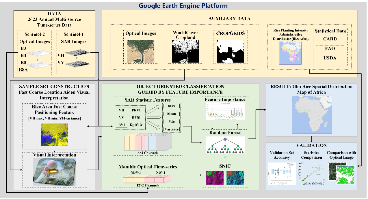
Flowchart of the proposed rice-mapping method. (Image by AIR)

86-10-68597521 (day)
86-10-68597289 (night)

52 Sanlihe Rd., Xicheng District,
Beijing, China (100864)
Copyright © 2002 - Chinese Academy of Sciences


