Newsroom


A team of researchers from the Institute of Applied Ecology of the Chinese Academy of Sciences has developed a new method to quantify the three-dimensional complexity of mountainous terrain. The novel tool, called the Terrain Complexity Index (TCI), offers a more accurate way to understand and predict key ecological factors like soil erosion and plant biodiversity in difficult-to-study landscapes.
The findings, published in Science of Remote Sensing, are expected to provide new insights for scientists in fields ranging from ecology to meteorology.
Terrain complexity is a term used to describe the intricate, often chaotic, physical structure of a landscape. Historically, quantifying this complexity has been a challenge because terrain features can look different depending on the scale at which they are measured. For example, a small hill might look smooth up close but is part of a larger, jagged mountain range.
The new TCI method addresses this issue by combining five different terrain features into a single, comprehensive index. These features include fractal dimension, a measure of how a surface's self-similarity structure changes with scale; entropy, which describes the disorder or randomness of terrain elements; and rugosity, a metric for surface roughness. Also included are volume filling ratio, which quantifies how well a terrain's volume is filled; and slope, the steepness of the ground.
Led by Academician ZHU Jiaojun, the researchers have developed the TCI using Digital Elevation Models (DEMs), which are digital files containing elevation data for a specific area. By analyzing these data, the researchers discovered that the individual terrain features they studied were all influenced by the terrain unit size being measured.
As the terrain unit size increased, the values for these features grew and eventually leveled off. The minimum terrain unit size required to accurately characterize these features was found to be directly related to the resolution of the DEM used. For instance, a high-resolution DEM of 0.5 meters required a minimum terrain unit size of 140 m by 140 m, while a lower-resolution 120-meter DEM needed a much larger 7.56 km by 7.56 km unit.
Using a 30-meter resolution DEM, the study demonstrated the TCI's predictive power. The individual terrain features could explain between 7% and 21% of the variation in annual soil water erosion (ASWE) and between 9% and 24% of the variation in vascular plant diversity. However, when the new TCI was used, its predictive capability was superior, outperforming any single feature by 2% to 10% for both soil erosion and plant diversity.
These results demonstrate that the TCI is a powerful new tool for forecasting how terrain influences complex ecological interactions and spatial patterns. The research provides a valuable new metric for scientists to better quantify and understand the three-dimensional structures of mountainous areas, paving the way for a deeper understanding of their ecosystems.
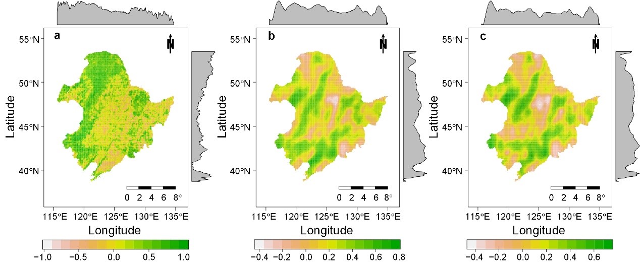
The spatial distribution of local correlations between the Terrain Complexity Index and different ecological variables, including (a) annual soil water erosion, (b) vascular plant phylogenetic richness, and (c) vascular plant species richness (Image by TENG Dexiong)