Newsroom


An international research team has developed the world's first 30-meter resolution dataset to track changes in land productivity, a crucial tool for fighting global land degradation. Published in Scientific Data, this innovation promises to help nations monitor progress towards Sustainable Development Goal (SDG) 15.3, which aims to achieve a "Land Degradation Neutrality" (LDN) world by 2030.
Land degradation, characterized by declining soil health, vegetation, and biodiversity, poses serious threats to food security, climate resilience, and ecosystems. To combat these challenges, the UN 2030 Agenda for Sustainable Development includes SDG target 15.3, which encourages countries to monitor land degradation and take action towards achieving LDN. A key indicator for this goal is Land Productivity Dynamics (LPD), which measures changes in vegetation health over time. Historically, global LPD datasets were limited to a coarse 250-meter resolution, making it difficult to identify small-scale degradation, such as overgrazed pastures or deforested areas.
Led by Prof. LI Xiaosong from the Aerospace Information Research Institute (AIR) of the Chinese Academy of Sciences, the research team collaborated with the UN Food and Agriculture Organization (FAO), Beijing Normal University, and other global institutions. They combined satellite imagery from Landsat-8 (at 30-meter resolution) and MODIS sensors to create a sharper, more reliable Normalized Difference Vegetation Index (NDVI)—a measure of plant health. Using Google Earth Engine, a powerful cloud-based platform for processing planetary-scale data, the team analyzed a decade's worth of observations (2013–2022) to generate the first global LPD map at 30-meter resolution. This level of detail allows scientists to detect subtle changes in farmland, forests, and grasslands that were previously undetectable.
The dataset was validated using multiple methods, achieving over 80% accuracy in identifying areas with declining land productivity. This precision is crucial for pinpointing "degradation hotspots," enabling governments to prioritize restoration efforts.
The United Nations Convention to Combat Desertification (UNCCD) has adopted this dataset for Small Island Developing States (SIDS)—nations that are particularly vulnerable to land loss—as the default dataset for SDG 15.3.1 reporting. Moreover, the algorithm and product have been included in the Good Practice Guidance for SDG 15.3.1 reporting.
The team plans to expand the dataset's applications, from guiding reforestation projects to monitoring drought impacts. As Prof. LI states, "This isn't just about creating better maps—it's about providing nations with the tools they need to restore their land." With the 2030 SDG deadline approaching, this high-resolution dataset could be a game-changer in the effort to protect Earth's vital resources.
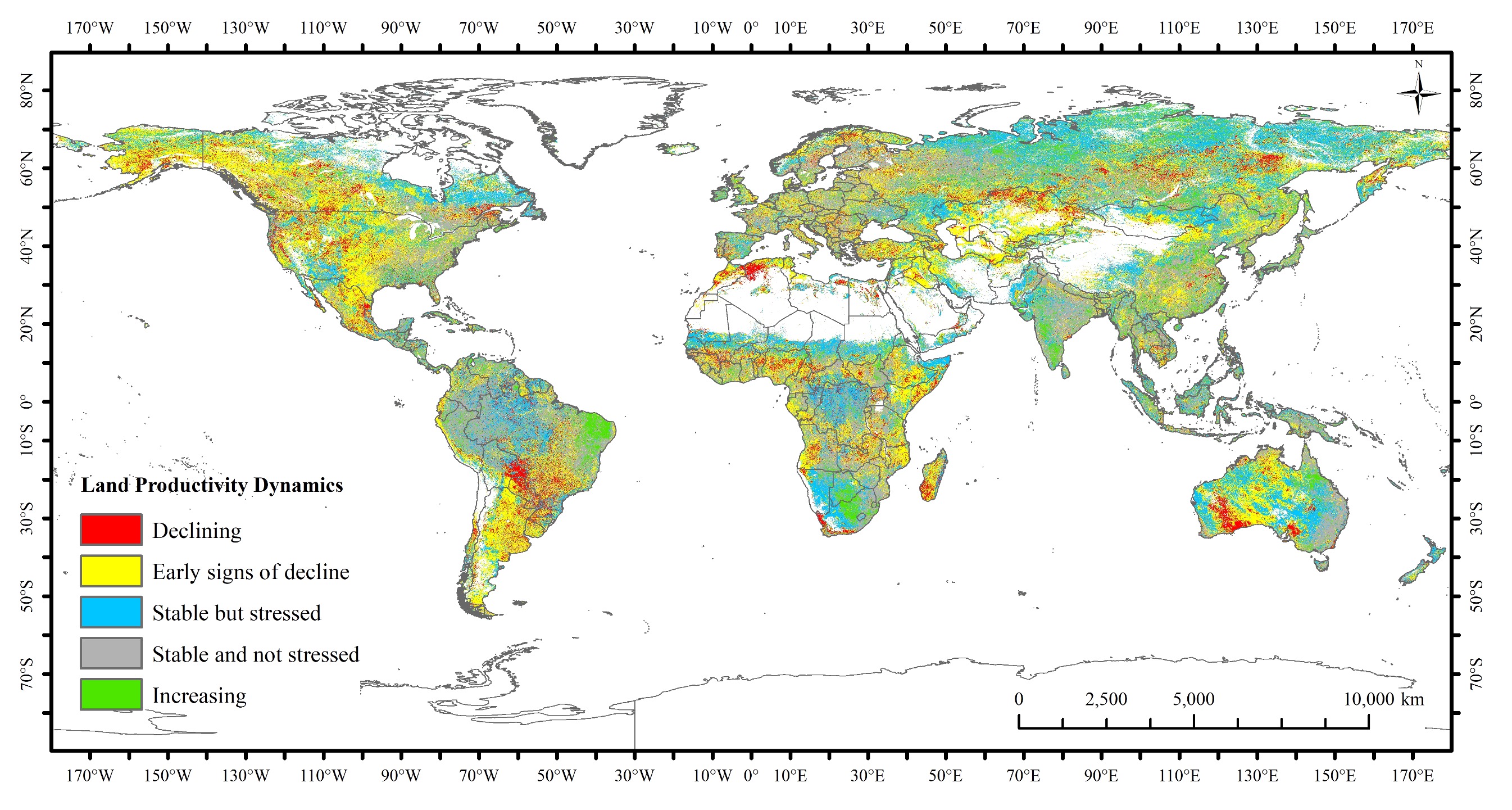
Global 30-meter LPD result. (Image by AIR)
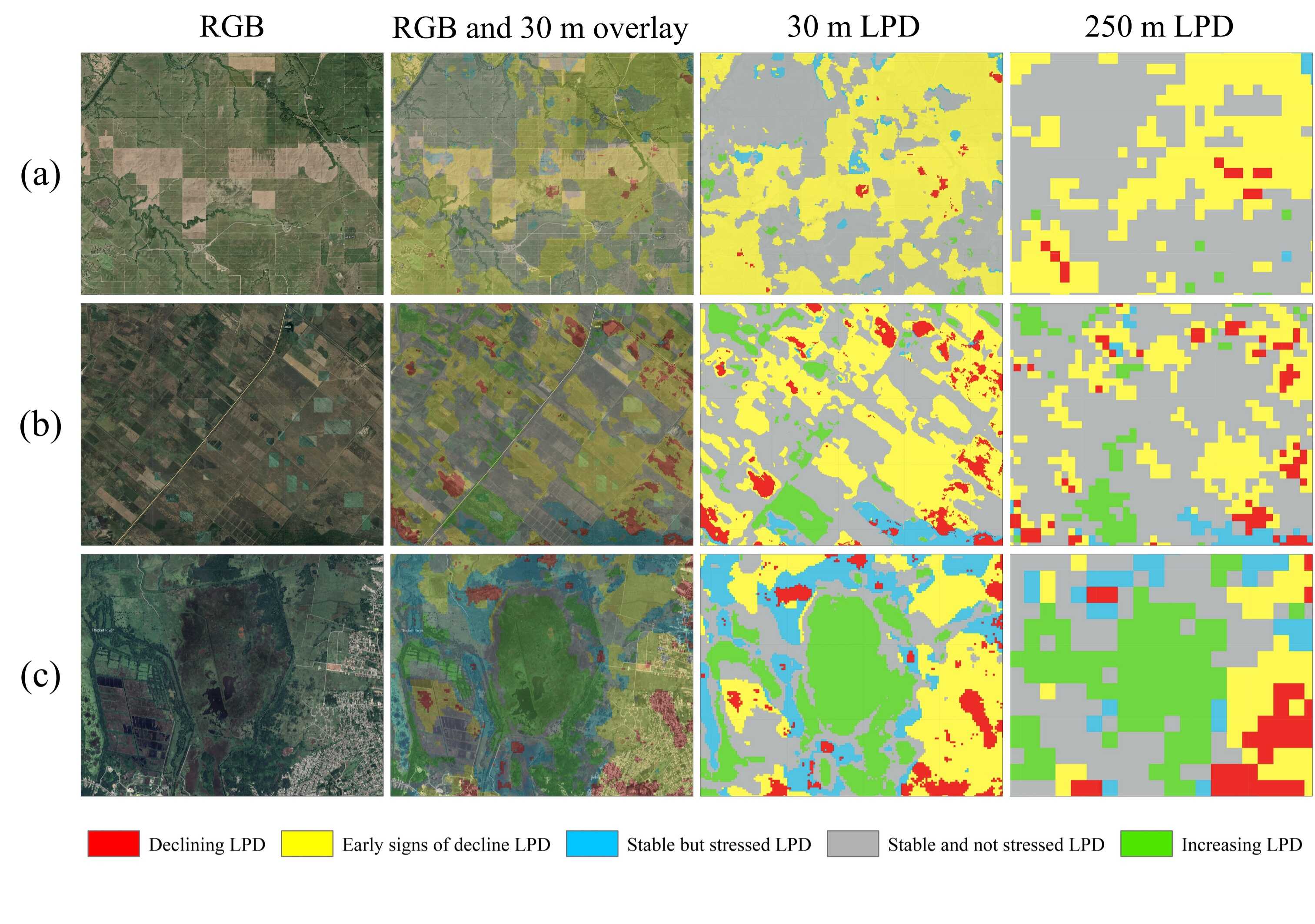
Comparison of LPD results for Small Island Developing States (SIDS). (Image by AIR)