
The El Niño-Southern Oscillation (ENSO) is the most important interannual signal in the tropical Pacific. This oscillation affects world-wide climate and can lead to different extratropical wave trains and climate responses due to the differences in sea surface temperature (SST) anomaly pattern.
"Previous studies generally demonstrated that the impacts of ESNO may be modulated by the Pacific Decadal Oscillation (PDO). In recent decade, a new type of El Niño event called the central Pacific (CP) El Niño received extensive attention." Prof. CHEN Wen from Institute of Atmospheric Physics of the Chinese Academy of Sciences explained the motivation of his team's recently published studies.
"This 'new type' of El Niño occurs more frequently after the 1990s and generates different climate responses compared to the conventional type, named as eastern Pacific (EP) El Niño. However, few investigations were devoted to discuss the cold phase of ENSO and whether the La Niña's impact to be interfered by the PDO."
CHEN's team investigated the combined impacts of PDO and two types of La Niña on climate anomalies in Europe. They found that the conjunction of negative PDO phase and La Niña events favors strong and significant North Atlantic Oscillation (NAO) pattern anomalies, but with opposite polarity for two different types.
The CP La Niña leads to a clear positive NAO signal accompanied by positive surface air temperature (SAT) anomaly and a dipolar-structure of wet north-dry south in Europe, while a negative NAO-like pattern can be observed for EP La Niña, generating reversed SAT and precipitation anomalies.
"We also look into different wave trains emanating from the North Pacific," Said CHEN, "with a typical negative Pacific-North America (PNA) wave train propagating to southeastern United States for CP type and a zonal wave train in the high latitudes propagating to Greenland for EP type, these wave trains are responsible for the formation of opposite NAO-like anomalies through the local synoptic eddy-mean flow interaction."
According to CHEN, these two distinct wave trains for CP and EP La Niña may be attributed to the differences in the location and intensity of anomalous convection induced by different types of SST anomaly as well as by the corresponding background westerly wind anomalies in the upper troposphere.
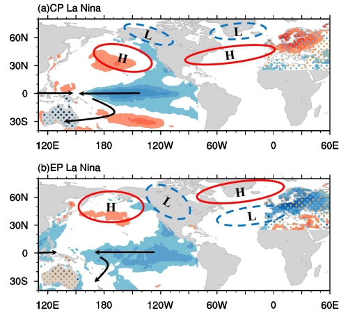
European winter and Australian summer climate anomalies associated with the two types of La Niña events. Color filling indicates the SST and SAT anomalies (unit: oC) with red (blue) as warm (cold). Dotted area indicates the rainfall anomalies with green (brown) as wet (dry). H (L) represents the anticyclonic (cyclonic) anomaly in the upper troposphere, respectively. The arrow indicates the wind in the lower troposphere. (Image by IAP)
In addition, the team also found that Australia summer rainfall anomalies are significantly different between these two types of La Niña events. It appears that Australian summer rainfall is only significantly impacted by CP La Niña events.

86-10-68597521 (day)
86-10-68597289 (night)

52 Sanlihe Rd., Xicheng District,
Beijing, China (100864)
Copyright © 2002 - Chinese Academy of Sciences


