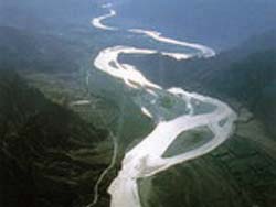
The Yangtze.
After tough work in the sloughy upper reaches of Dam Qu, an important upriver tributary believed to be the most possible real source of the Yangtze, the expedition goes on to explore another major tributary of this river, the Togton River on 7 October, 2008. This will be the last lap for the fieldwork of this large-scale expedition, which is expected to unveil the real sources of three major rivers in Asia, namely the Yellow, Yangtze and Lancang.The team has completed the investigation into the source areas of the Yellow and Lancang rivers.
The expedition, according to reports by
Xinhua, will camp in the depth of the Gêladaindong Mountain in the Tanggula (Dangla) Mountain Range at an elevation of over 5,500 meters above sea level, and start their journey into the Mountain to search for the source of the Togton They will perform observation and research on the spatial geographic changes of this area, to provide scientific evidence for the awaited official release of the important geographic information.
The 6,300km-long Yangtze River ranks the third longest in the world. According to the principal investigator of the expedition, Prof. LIU Shaochuang from the CAS Institute of Remote Sensing Applications, it has three major upriver tributaries, namely the Dam Qu, the Togton, and the Qumar. Among them, the Togton was officially identified as the source of Yangtze in the 1970s by the Yangtze River Water Resources Commission under the Ministry of Water Resources of China. This conclusion has stirred a big controversy at home and abroad, with many scholars arguing that it neglected the Dam Qu, the upriver tributary in the south whose length, discharge and drainage area are all bigger than those of the Togton. The new move of expedition is anticipated to clear the clouds with more sufficient and precise data.
Once entering the source area of the Togton, according to reports, the team will first stop at the confluence of the Dam Qu and the Togton to measure its coordinates and elevation, and meanwhile conduct measurements, collection of data and comprehensive studies concerning the meteorological, hydrological, glaciological, gravity, geological, geographical and other sides of local environmental situation. The next phase of the fieldwork will involve climbing on the Gêladaindong Mountain to investigate the glaciers there.
The expedition marks the first effort of China to precisely locate the real sources of the three major rivers at the same time. After the fieldwork, the groups under the expedition, respectively in charge of subprojects in surveying, mapping and remote sensing, hydrology, geology and glaciology, and meteorology and geography will each compile reports of investigation for the subprojects, thereby to provide scientific evidence for determining the exact geographic locations of the real sources. The conclusion will be made by the end of November 2008, according to the work plan of the expedition.


