
To a certain extent Urban Heat Island(UHI) influences the residents’ comfort and health. Understanding of how urban landscape affect the thermal environment is crucial for urban ecological planning and sustainable development.
Ground and Remote Sensing-synchronized measurements on Land Surface Temperature(LST), surface radiation and heat flux components and atmosphere elements were implemented in Beijing, China, by a research team hosted from Institute of Geographic Sciences and Natural Resources Research (IGSNRR), Chinese Academy of Sciences.
The researchers used portable infrared thermometers, thermal infrared imagers, Landsat TM and MODIS to measure and analyze the relationship between urban landscape structure and thermal environment.
Urban impervious surfaces were usually recognized the main causes on UHI. However, the study shows that the intra-urban LST variations result largely from urban land-cover and building materials.
"The differences were caused by different fractions of sensible heat or latent heat flux in net radiation. Urban impervious surface was primarily composed of sensible heat, with a Bowen ratio (H/LE) of 4.03. For urban green space, latent heat fraction (0.58) was higher than sensible heat because of vegetation transpiration. ” Dr. KUANG Wenhui said.
Variations in building materials and urban structure significantly influenced the spatial pattern of LSTs in urban areas, in contrast to elevation and vegetation cover are the major determinants of the LST pattern in rural areas.
"To alleviate urban heat island intensity, urban planners and policymakers should pay special attention to the selection of appropriate building materials, the reasonable arrangement of urban structures, and the rational design of landscape components.” said the researchers.
The related work has been published in Landscape Ecology (Kuang W H, Liu Y, Dou Y Y, et al. What are hot and what are not in an urban landscape: quantifying and explaining the land surface temperature pattern in Beijing, China. Landscape Ecology. 2015. DOI: 10.1007/s10980-014-0128-6.).
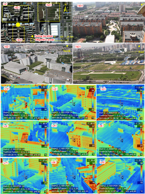
The locations for observing land surface temperatures of various urban structures and landscape components (i.e., buildings, plaza, and park) in the Maple Oasis residential area (Z1 in Fig. 1) and the corresponding infrared images obtained from thermal infrared imagers. a The observation range of the thermal infrared imagers (yellow boxes) and observation position (yellow circle); b1–b3 landscape pictures of buildings, plaza, and green space, respectively. c1–c9 The images obtained from thermal infrared imagers; c1, c2, and c3 are the thermal infrared images of b1, b2, and b3, respectively; c4–c6 represent impervious surfaces of buildings and plaza; c7–c9 represent the green space (Image by KUANG).

86-10-68597521 (day)
86-10-68597289 (night)

86-10-68511095 (day)
86-10-68512458 (night)

cas_en@cas.cn

52 Sanlihe Rd., Xicheng District,
Beijing, China (100864)
Copyright © 2002 - Chinese Academy of Sciences


